By Dennis Hanagan –
Cherry Street.
Under a plan endorsed by city council in July, the mouth of the Don River will be re-routed and take on a more natural, winding appearance in between the Keating Channel and the Ship Channel and will have large areas of parkland on both banks.
As well, around the mouth and on the north side of the Keating Channel will be mixed-use communities with 13,000 new residential units and 500,000 square feet of commercial and retail space.
This is the new look taking shape for an area that was once the largest natural wetlands on the Great Lakes—and which in 1914 was eliminated when the Don’s mouth was redirected into the concrete-lined Keating Channel, and the surrounding wetlands were filled in to be used by industry.

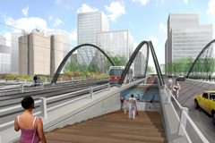
Lower Don Lands looking east.
Council’s July 9 endorsement of the project, known as the Lower Don Lands Plan, means it can be submitted to the Ministry of the Environment for approval under the Environmental Assessment Act.
As well, the official plan amendment and new zoning by-law can be submitted to the Ministry of Municipal Affairs and Housing, and to the Ministry of Natural Resources to make sure the plan is consistent with provincial flood management policies.
Following approval by the ministries, the official plan amendment and zoning by-law will go back to city council in August for final approval.
The plan takes in a 308-acre area bounded by Parliament St., the Don Roadway, the rail corridor on the north, and the ship channel.

Lower Don in the summer.
It comes from Waterfront Toronto, headquartered at 20 Bay St. and created in 2001 by the governments of Canada and Ontario and the city to lead the renewal of Toronto’s waterfront.
“Revitalization of the Lower Don Lands is an integral part of overall waterfront revitalization,” says Waterfront Toronto’s president John Campbell. “The renaturalized Don River will become the centerpiece of a 21st century, mixed-use neighbourhood,”
Highlights of the plan envision five boat launches, three schools with recreation centres, three cultural centres, one library, and six LRT stops. Street layouts will provide natural cooling effects of summer breezes and shade, and protection from winter winds.
The plan allows for the Keating Channel lined with public space, canal-side cafés and traversed by four new bridges. Also, rainwater will be harvested from building rooftops to supply the wetlands and the Don River.
Waterfront Toronto has held three public meetings for the Lower Don Lands environmental assessment process and plans to hold more.